
The Mike Mellor Way
A circular walk through Olney, Emberton, Sherington, and Petsoe End, created in memory of Mike Mellor (1944 – 2001), Rights of Way Officer for the then Milton Keynes Borough Council.
Mike's pioneering work has been commended for its originality and enduring success. He was instrumental to the establishment of the headland maintenance scheme in 1992, which has proved highly successful in maintaining paths whilst engaging farmers and local communities. It was the first scheme of its kind in England and continues to engender cooperation and respect to this day.
This walk honours his memory, talking the traveller on a delightful journey through some of Milton Keynes’ finest countryside.
Need to know
- Distance: 9.5 miles (15.22km)
- Time to walk: Roughly four hours.
- Difficulty: Mainly mixture of field path & quiet lane walking.
- Parking: Car Parks in Olney, road parking in Emberton or Sherington, or Emberton Country Park.
- Public toilets: Olney town centre and Emberton Country Park. White Hart public house Sherington.
Route description
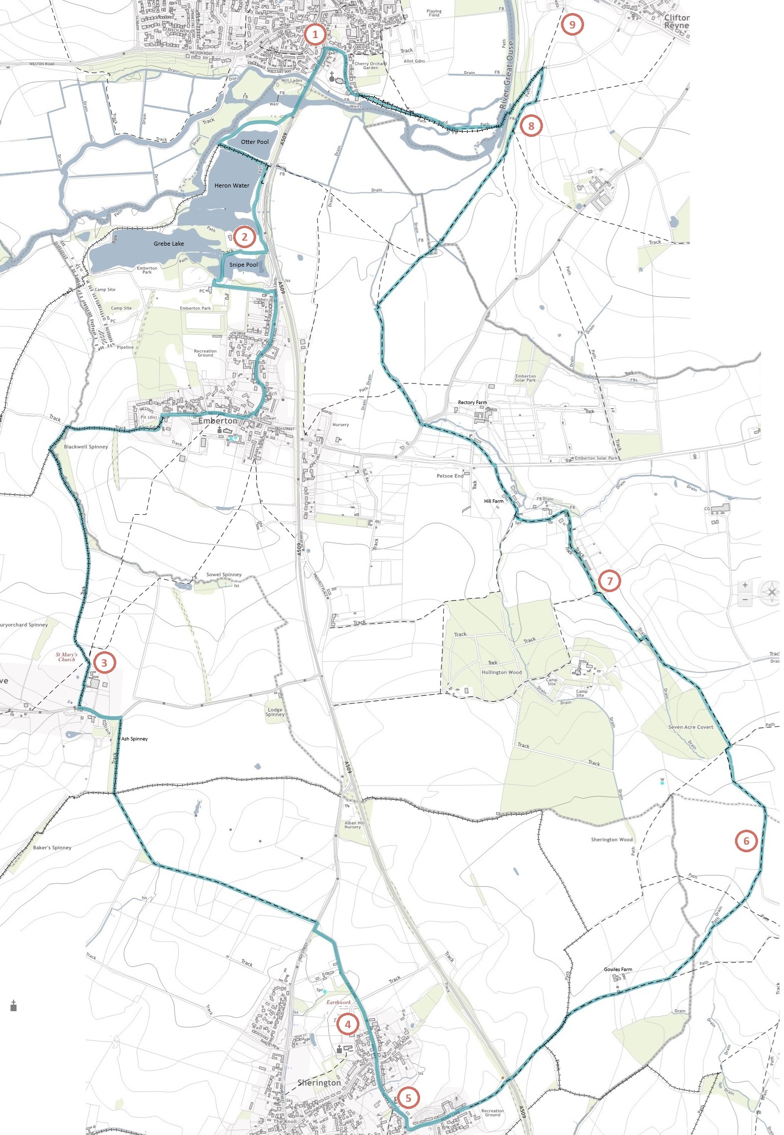
The route is well waymarked with 'Mike Mellor Way' markers.
You can start this circular walk from any point - these directions join the route to the west of Clifton Reynes, then take an anti-clockwise direction through Olney, Emberton, Sherington, Petsoe End and back to Clifton Reynes.
Section 1: River Great Ouse and Olney
- From Clifton Reynes Footpath 4 the route heads north up the hill, travelling alongside a small woodland to reach Clifton Reynes FP1. Here it passes through a bridle gate and follows along a hillside path.
- At a four-way junction, there is a sharp hairpin left (south-eastwards) to turn onto Clifton Reynes BW2, which travels down a steep hill. There are hand railings along some of the path which becomes very narrow. There are three bridges taking you across the River Great Ouse.
- Once over the river, the route follows the footpath through the field gate
- Pass over another footbridge, with Olney church ahead.
- The route follows Olney BW2/2A towards the church - a bridleway gate takes you along footway on to Church Street.
- Follow past the church to join Bridge Street where it turns left (southwards). The route follows along the footway next to the road and over the bridge.
Section 2: Emberton Country Park
- Take the signed footpath access off to the right to enter Emberton Country Park. Join the driveway track to the north of Otter Pool and head in a southwest direction.
- Further along the driveway track the route takes the bridlepath waymarked eastwards (Emberton BW11) between Otter Pool and Heron Water, to reach Emberton FP11A, and follows the track along the edge of Heron Water.
- For those walking without dogs, an alternative option is to walk down the bridleway to the west of Heron Water instead, then to cut east between two lakes through a narrow wildlife corridor, re-joining the marked route near the sailing club (///limelight.aspect.fattest).
- For those following the main route, after about 500 metres take the path westwards, walking to the south of the sailing club then following the wooded path south between Grebe Lake and Snipe Pool. Take the main park road east to the café and on to Olney Road.
- Follow the road south into Emberton village
- Turn right (westwards) at the T-junction with West Lane, and follow the footway in passed the church.
- Turn left (southwards) at the allotments onto Emberton BW3
Section 3: Emberton to Filgrave
- Follow the bridleway along the track as it heads westwards, turning south once you reach Blackwell Spinney. At the corner of the woodland, at the bridleway junction, turn left to keep following the woodland edge to the south east.
- Continue following the bridleway south along field edges.
- Continue down Tyringham & Filgrave BW2, walking past Rectory Farm down a private road to join the public road. Head left (east).
- Follow the road to Ash Spinney - just passed the woodland there is a layby on the bend, and the start of Tyringham & Filgrave BW3. Take this route south.
Section 4: Filgrave to Sherington
- Follow the bridleway south along the eastern edge of Ash Spinney to reach a junction of paths. Continue straight on, heading in a south-easterly direction.
- The route follows the headland for several miles, in a south-easterly direction, until it reaches Sherington High Street through a field gate close to the road. Cross over the road onto Gun Lane.
- Continue down Gun Lane - at the junction with Park Road, continue straight onto School Lane.
- At the T-Junction, turn left onto Crofts End/Petty Lane. Head north-east over the road bridge (A509)
Section 5: Sherington, Petsoe End and the River Great Ouse
- Continue north east at the track junction, onto Sherington BW8.
- At the next junction, take Sherington FP12 east, passing Gowles Farm.
- At the next footpath junction, take the left hand path (Sherington FP13) to start heading north-east.
- At the next footpath junction, continue straight onto Chichley FP7. This joins a track heading north, becoming Emberton FP14 at the track end, where the route heads north-west towards woodland.
- Once you reach Seven Acre Covert, the route cuts through the corner of the woodland, as you turn right onto Emberton FP15 then immediately left onto Emberton FP14. Once you emerge back on to the field edge, keep following the eastern edge of the wood.
- Follow the field edge, cutting through to the western side of the hedgeline part way along.
- Continue along the field edge path to the corner of the field. At the footpath junction, turn north to join Emberton FP8. This turns into a single-track lane, passing a farm and eventually a vehicle barrier from where it becomes a fully road surfaced lane.
- Once At the T-junction, turn right onto Emberton FP5 which continues north up Petsoe End road. Pass Hill Farm on your left, and follow the lane up to the T-Junction.
- Emberton FP5 crosses from the single-track lane over the road and through the footpath gate opposite at the road junction (hidden by some vegetation, but signposted) it enters grazed fields and crosses a track to Rectory Farm, to continue over stile and into some more grazed fields.
- At the other end of the field, the stile crossing is in the corner, and from here crosses over a road, and passes through a gap next to the field gate onto an arable headland footpath.
- The route travels straight over the first footpath junction, continuing to follow Emberton FP5 northwards.
- At the next footpath junction, which is just after crossing over into the field to the east, take the right hand path (Emberton FP13) which heads across the field to the north east.
- Once across (at certain times of year this can be difficult, so take care) it crosses a footbridge, where it joins Clifton Reynes FP4 heading north east.
- Continue across the fields to join Clifton Reynes FP1 - this track takes you north along the eastern edge of some trees, and back to the start of the walk.
Route map
Points of interest
- Olney, thought to have been settled since the Roman period and once the centre of the local lacemaking industry, has hosted a pancake race since 1445, with women of the town racing from the marketplace to the Church of St Peter and St Paul.
- Emberton Country Park, the first of its kind in the UK, spans 200 acres and was created in 1965 from an old gravel works. The park is home to a wide variety of wildfowl, and if you’re lucky you might spot a Kingfisher or Green Woodpecker. Take the time to admire the Dragonflies and Damselflies as you walk through – over 20 species have been counted here.
- Follow in the footsteps of our ancestors as you walk along a holloway (sunken lane) through the remains of a deserted medieval settlement, thought to have been abandoned by the late 16th century. The church of St Mary was dismantled over time and parts used to repair the local mill and parsonage. Other remains include the manor house, crofts, a fishpond, and ridge and furrow.
- The church in Sherington (old English name meaning a farm associated with the family of Scira) dates from the mid-13th century, and is the only St Laud’s in the country.
- The White Hart has been serving the people of Sherington since the mid 18th century – it is part of the Sherington Conservation area which covers much of the old village.
- This walk crosses 4 of the 14 landscape character assessments (LCAs) within Milton Keynes, broad landscape divisions that record what makes each area distinctive:
* The south-east corner lies in the ‘North Crawley Clay Plateau Farmland with Tributaries’ LCA, the uplands of the area – it is relatively sparsely settled, the land primarily covered with large arable fields with some isolated pockets of woodland and mature hedgerow trees
* Olney lies in the ‘Ouse North Undulating Clay Farmland’ LCA, an area characterised by historic limestone villages and parklands, with panoramic views over the river valley.
* Emberton Country Park is part of the ‘Ouse Rural River Valley’ LCA. This area is characterised by weirs and historic mills, riverside pastures and a generally tranquil nature
* Sherington is part of a broad band of the ‘Ouse South Undulating Clay Farmland’ LCA, which covers much of rural Milton Keynes. This is a landscape of limestone villages, paddocks, church spires/towers, and gently undulating farmland. - As you head north towards Petsoe, look east to see the ancient woodland of Hollington Wood. Existing for over 400 years, ancient woodlands contain irreplaceable habitats and are havens for native species such as bluebells.
- Look to the east as you walk this section for impressive views across the River Great Ouse towards the Church of St Peter and St Paul in Olney. The River Great Ouse is the longest of the ‘Ouse’ rivers in Britain - the name is thought to mean ‘water’ or ‘slow flowing river’. It is the fifth longest river in Britain, rising in West Northamptonshire and flowing out to the Wash near Kings Lynn.
- Just off-route is the village of Clifton Reynes – the church of St Mary is of Norman origin, and is unusual for the area, being completely ringed with battlements (castellations).